

The weather bureau has warned of heavy rain and destructive winds of up to 125km/h for Brisbane from tonight as central Queensland is slammed by severe weather.
The bureau issued the alert this evening and warned of possible flash and riverine flooding.
In the next few days about 300mm of rain is expected in Wivenhoe Dam catchment, upstream of Brisbane, and coastal areas could get as much as 500mm.
Premier Campbell Newman said controlled releases from the dam are continuing and there is no doubt it will be able to cope with the influx of rainwater in the coming days.
“We can absorb that flood,” he said.
The biggest risk will come from suburban creeks in the Gold and Sunshine Coast and greater Brisbane area.
Gladstone is facing a dramatic new flood threat as two other towns in the region face an unprecedented deluge as ex-cyclone Oswald lingers over the region.
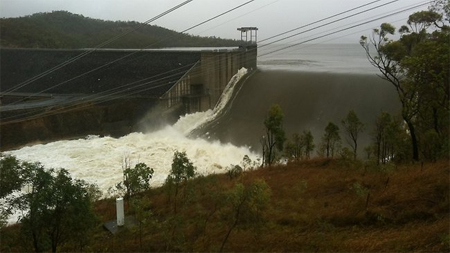
Torrential rain topped a metre in 48 hours and has swollen the Boyne River to two metres higher than the previous record.
About five metres of water is pouring over the spillway of the Awoonga Dam into the Boyne, just south of Gladstone.
Tannum Sands and Boyne Island, at the mouth of the Boyne River, narrowly escaped inundation on Saturday.
But they may not be so lucky when an extraordinarily high tide hits on Sunday morning.
“We’re now getting ready for the next time when we think we’ll have the biggest problem and that’s at the high tide on Sunday morning,” Gladstone Mayor Gail Sellers told AAP.
About 2000 people have been asked to evacuate.
Queensland Premier Campbell Newman said a saddle dam off the Awoonga Dam is close to overflowing, which would put 500 homes in peril.
He said the government is considering mandatory evacuations.
“That’s my main concern,” he said.
Further south, a mini-tornado slammed into Bargara near Bundaberg, leaving at least two people badly hurt after their car was hit by a pine tree blown over during the storm.
A number of local buildings, including a supermarket, were reported to be badly damaged.
Premier Campbell Newman said Gladstone and Bargara had been declared disaster areas.
In Gladstone, the region has had about 700mm in the last four days – and is bracing for another 200mm to 400mm in the next 24 hours.
Coupled with an extraordinarily high tide tomorrow, authorities fear flooding around Tannum Sands and Boyne Island – areas which narrowly escaped inundation today – and they have ordered residents to leave the towns of Jambin and Goovigen as a water volume almost six times greater than their last flood approaches.
Earlier
With 300mm of rain forecast to soak the region today and tomorrow, Premier Campbell Newman yesterday gave the order for just under 50,000 million litres to be drawn from Wivenhoe and North Pine Dams, a three per cent reduction.
With ex-Tropical Cyclone Oswald drenching north Queensland, it is the southeast’s turn to receive a bucketing as the low creates flash flooding from the Sunshine Coast to the New South Wales border.
In central Queensland, swiftwater rescue teams made 20 rescues including plucking eight people to safety after their car was swept off the Capricorn Highway and a teenager was saved from a ranging torrent by swift water rescue teams.
Source: Courier Mail “Warnings of heavy rain and destructive winds for Brisbane until Monday”Related articles
- Live coverage: Flood havoc as rain lashes Qld (abc.net.au)
- Evacuations underway in Gladstone; Brisbane on alert (stuff.co.nz)
- Tragic scenes as fires destroy homes across Tasmania, Australia (craighill.net)
Discover more from Craig Hill
Subscribe to get the latest posts sent to your email.

My best wishes to the people of Brisbane for a speedy recovery from this disaster. I hope you all are able to stay safe and get the help you need as soon as possible.